Saturday, September 30, 2017

John Day Fossil Beds National Monument

I spent the day at the John Day Fossil Beds National Monument (about 100 miles+ from Bend).  It turned out to be a fascinating day.  Named for the nearby river, the John Day Fossil Beds expose extraordinarily well preserved specimens.  Also remarkable is the great number and variety of fossils:  entire communities have been uncovered.   The John Day Fossil Beds are dispersed across 20,000 square miles of eastern Oregon. The beds have yielded such a wealth of information that scientists can assemble and reconstruct ancient ecosystems.  Eight of these "assemblages" are re-created in the museum gallery of the Thomas Condon Paleontology Center.

The National Monument encompasses 14,000 acres in three separate units:  Painted Hills, Sheep Rock and Clarno.  Driving routes between units pass by stunning scenery, colorful geological features and abundant wildlife.  The trails provide even more.

Larger picture is Cathedral Rock - a colorful greenish outcrop of the John Day Formation, capped with reddish ignimbrite
The Thomas Condon Paleontology Center is located in the Sheep Rock Unit and that is where I started my day.  The Center is also the park visitor center and fossil museum.  Picture windows let you view the working laboratory and collections room with over 60,000 specimens.  In the fossil museum gallery, you can walk through nearly 50 million years of the Age of Mammals.  Hundreds of fossil specimens are displayed, along with eight large murals depicting plants and animals of the time.  Each display explains the geology then and now.

Sheep Rock is the upper left picture
I think the monument would be spectacular at sunset, especially the Painted Hills Unit.  Even if you think you're not "into science," it is a beautiful place to spend a day.  Just to drive through is a pleasant experience to your scenes, even if you don't stop or take any of the walks.


John Day Highway #19 is also the Journey Through Time scenic byway ... an apt name.


Wednesday, September 27, 2017

Crater Lake


 Yes, the lake is really that blue!  The color is due to the clarity of the water.  The lake (1,943 feet deep) lies inside a caldera, or volcanic basin, and was created when the 12,000 foot high Mount Mazama collapsed 7,700 years ago following a large eruption. Because the lake is filled almost entirely by snowfall, it is one of the clearest lakes in the world.  It has set a record of 143 feet of clarity!  It does not have any ingress or egress, so the water is either snowfall or rain.  This area receives 44 inches of snow every year!

It is also the deepest lake in the United States and the seventh deepest lake in the world.

You might find these interesting:

Facts and Figures

  • Crater Lake is the deepest lake in the United States
  • The second deepest lake in the Western Hemisphere
  • The seventh deepest lake in the world
  • Maximum lake depth: 1932 feet
  • Average lake depth: 1500 feet
  • Maximum lake width: 6 miles
  • Lake surface elevation: 6176 feet
  • Wizard Island elevation: 6940 feet
  • Wizard Island height above water: 764 feet
  • Hillman Peak, highest point on rim: 8151 feet
  • Mount Scott, highest point in park: 8929 feet
  • Union Peak: 7709 feet
  • Rim Village elevation: 7100 feet
  • Precipitation, yearly average: 66 inches
  • Snowfall, yearly average: 44 feet
  • Maximum snow depth at Park Headquarters: 21 feet
  • Park Size: 183,224 acres
A great place to visit!

Saturday, September 23, 2017

Bend, Oregon (Part 1)

I took part of the Elkhorn Drive and Journey Through Time Scenic Byways on my way to Bend.  Oregon Highway 26 is a good road, and very pretty, and I had it mostly to myself.  There were a couple of 5400ft summits, with a couple more almost that high, so you need to be conscience of the weather.  The scenery changes from farms and ranches, to mountains, and back again, crossing and following rivers, and then turning into High Desert shrubbery.

There is a "shoe" tree about mm88 off to the side of the road; it is completely covered in pairs of shoes tied together by the laces and hanging over the branches! I've seen these from time to time, but not as completely covered as this one. I see so many "interesting" and beautiful things I would like to photograph, but it just isn't possible solo in a big rig.

Two things you quickly learn about Bend:  They must be the round-about capital of the world, no kidding.  In the center of each round-about is a nice planting of flowers and shrubs with a unique metal sculpture in the center, some of which are really interesting.  Second, it is must be the gateway to the outdoors because there is an abundance of outfitting businesses - and frequently there is a canoe, kayak, mountain bike, etc. strapped on a vehicle.  Also, fishing is big here.

Beside Highway 97, you can see a big cinder cone mountain .... Lava Butte
Lava Butte in Newberry National Volcanic Monument

Here are some views from the top ....
The center picture is the road up to Lava Butte
View of Mt. Bachelor from Lava Butte

There is a short walk (about 1/4 mile) around the edge of the crater "hole," and beautiful views of the Cascades.


I also made a trip to Tumalo Falls, about 20 miles SW of Bend ...
Tumalo Falls has been called "the tallest and most impressive waterfall along Tumalo Creek". The 97 ft. vertical curtain waterfall pours out into Tumalo Creek at a pitch of 90 degrees.
And then I found ... Built in 1963, Rock O' The Range Covered Bridge passes over Swalley Canal for a total of 42 ft., making it one of the shorter covered bridges in Oregon.
Look at the picture in the upper left - you had to cross the bridge on these support "ramps" (you can see them in the other pictures as well).

Lots more to see ..... unless it snows.  It's been in the 30s at night and may get up as high as 50 degrees by afternoon; the sky/clouds look ominousness, but no rain so far.  They close this campground on October 1st because of snow.  I'm hoping it will warm up next week for a drive to Crater Lake!

Sunday, September 17, 2017

A week in Baker City, Oregon (the Oregon side of Hells Canyon)

Before I go on, I forgot to show you what I found in Cottonwood, Idaho - the World's Largest Beagle.  This is actually a dog park; the large beagle, Sweet Willy, is a bed and breakfast and the fire hydrant surrounds a portable outhouse for humans.

Now, back to Oregon ...

The first sixty miles or so on I-95 is a trip - I changed time zones 5 times and crossed the Little Salmon River an equal number of times.  I bet it is confusing to the residents of this area as to what time zone they are currently in!

I also crossed the 45th parallel, half way point between the equator and the north pole.

As I travel around I often think of the wagon trains - with my diesel engine pulling my "wagon" up over the hills and mountains and I'm trying to hold my speed on the way down  .... to do this in a wagon and on foot .without even the benefit of a road; the hardships and hard lives these people had  ... so  imagine my excitement to find the Oregon Trail Interpretive Center in Baker City.  This is a great place.  They have live, active discussions on surviving the Oregon Train, Women of the Oregon Trail, Pioneer demos, packing for the journey, snippets of their daily life, cooking on the trail, mending wagon wheels, crossing rivers, etc .... and wonderful displays and great movies giving you a great sense of what it was like .... it is NOT like you see in the movies! The part I enjoyed the most, I think, were the actual journals from the travelers and the narratives read from them along with the displays and talks.  They were very interesting.  It is a great place to visit.

I'm glad I did my jet boat ride on the Snake River on the Idaho side of Hells Canyon rather than waiting to do it now.  It is significantly colder this week than last ... 65 degrees as a high; 35 degrees as the low.

The Hells Canyon Scenic Byway on the Oregon side is again an "open range" area.  I find it curious that you see deer that have been hit by cars laying aside the road, but you never see any cows that have been hit and killed.  Amazing because, beside being bigger and slower moving that deer, you can take a curve and find several cows in the road without warning .... you just wait until they move out of your way before you continue.

I ended up doing this drive in two days instead of one because I started out late, and then took a side trip that ate 2 hours of my day without result.  When my GPS wanted me to turn onto a hiking path that wasn't wide enough for a car, I had to go back to where I began.  All and all that added an extra 140 miles onto the drive.

I combined the Grande Tour Route with the Hells Canyon Byway and this is what I saw ...

The drive started out following the river's corkscrew course upstream through cherry orchards and crop fields.  FYI Oregon is the nation's leading producer of peppermint.  The tour passes through Cove, a small town known for its Ascension Chapel, an 1869 episcopal church once visited by Desmond Tutu.


Union County Museum


On through Union (a nice museum), Imbler, known as the “Grass Seed Capital of the World,” there are numerous Century Farms in the area; Elgin, the former location of Fort Baker and a trading area since the 1880s, is the gateway to the Wallowa-Whitman National Forest. Minam, Wallowa, Lostine, Enterprise (the largest of the Wallow Valley communities) and Joseph. Joseph is named for Chief Joseph of the Nez Perce Tribe; it is a cute art community with shops.


I did make the drive up to the Hells Canyon Overlook - well worth it.


There are three Idaho Power hydroelectric dams on the Snake River in Hells Canyon – Hells Canyon Dam (which I saw on my jet boat ride), Oxbow Dam and Brownlee Dam.  The second two weren’t much to photograph, but the reservoirs were beautiful; the water was like glass.

Oxbow Reservoir

Brownlee Reservoir

At this point I took a side trip to Cambridge, Idaho (population 360).  I was told there was an "award-winning" museum, but it was under construction, so I had lunch.

Outside of Halfway, at mile post #52, there is a marker for the Tim Goodall Wagon Train route of 1862 and the Hole-in-the Wall Landslide between mile posts #30 & #31. This turnout overlooks a 1984 landslide that covered the road and temporarily dammed the Powder River.


I also visited the Baker Heritage Museum in Baker City.

Wednesday I head for Bend ....

Tuesday, September 12, 2017

A Week in White Bird, Idaho (on the Idaho side of Hells Canyon)

I drove from Newport, Washington south to White Bird, Idaho ... into the thick of the smoke from the wildfires (mostly from the Columbia River Gorge fire, but then White Bird is located near Montana, Oregon and Washington, so I received the benefit from all of the fires!).  Not only was visibility bad (the haze and smoke were like a fog), the air quality about chocked me.  You could hardly see the trees and the sun was a glowing red ball in the sky.  It gave very strange reflections off surfaces.  It was so bad, business are advertising "smoke free inside."  I was disappointed to take the scenic drives this week and not be able to see anything.

Because of the location, I didn't have cell or internet coverage (hence the delay of this blog); always a challenge when living on the road.

US 95 is the Nez Perce Highway.  Take your time on this drive; there are frequent turnouts for historical  information  about the Nez Perce Indians and this area.  They are pretty interesting.  Unfortunately, the smoke was so bad that at all of the overlooks all you could see was white.

A little history about Hells Canyon:  Early explorers referred to the gorge as Box Canyon or Snake River Canyon.  The first reference to Hells Canyon appeared in an 1895 edition of McCurdy's Marine History of the Pacific Northwest.  The canyon plunges 8,913 feet and 1 1/2 miles from its summit (He Devil Mountain is 9,393 feet above sea level) to the mouth of Granite Creek.  It is North America's deepest river gorge (deeper than the Grand Canyon).


My first "drive" after getting set up, was to Pittsburg Landing.  Pittsburg Landing is the only access to the Snake River in this part of Idaho.  It is a 17 mile drive on (of course) a gravel road.   Little did I realize I would be doing this drive twice (I would have postponed this one).   This is just a couple snaps of the road on my GPS .... It is so steep, chains are required.

It was a good thing I was driving slowly, because at one point a deer leaped over the fence and landed on the road right in front of my car.  It about give me a heart attack.


The drive to Riggins was very pleasant, along the "River of No Return"; something about driving alongside a river is very relaxing.

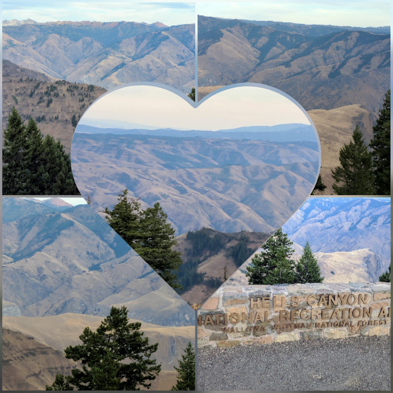
Another drive was to Heavens Gate Lookout.  This one I was very disappointed to miss!  You have to drive 19 miles on Seven Devils Road.  From the Lookout you can see Oregon, Idaho, Washington and Montana.  The road was kind of a "white knuckle" but I was rewarded by some wild horses and cattle (there is always cattle on the roads; it is open range here). 

In this picture, the upper left corner is a snap of the road; it was like driving on a dry river bed with rocks, only there was an 8,000 foot cliff on the side of the road and no guard rails! It felt like I was at the edge of the world and I could fall off.  The upper right corner is the view from the Lookout.  That grayish shadow is more smoke coming from one of the fires.


I also took the Old White Bird Hill Backcountry Drive (again couldn't see anything but smoke).  It was considered an engineering feat in its day as it zigzagged 2,900 feet gaining 4,429 feet in elevation in 14 miles.  Prison labor helped construct the road.  It was bypassed by the newer Hwy 95 and now has little traffic.  When you drive over this bridge, White Bird is the town below.  The elevation here is about 4,500 feet.
I am within 10 miles of a Time Zone change in two directions so it makes it a little challenging to know which clock is correct sometimes.

I did stop to look at the White Bird Battlefield (what I could see of it) and was again amazed at the feat of the soldiers to haul themselves and their artillery up and down those hills.  They must be part billy goat ... The first battle of the Nez Perce Was was fought here on June 17, 1877.  When soldiers arrived in the area, they fired upon Nez Perce who were waving a white flag of peace, beginning the fight.  How sad.

The Tolo Lake Mammoths:  In 1994, heavy equipment operators, completing a rehabilitation project at Tolo Lake, discovered fossils that turned out to be mammoth and bison.  To perpetuate the interest in the discovery, some local citizens banded together to purchase a life-size skeletal replica of a mammoth and built a shelter to house it.
 

 I always joke that you can always find a Walmart (the reason I get my prescriptions filled there), but White Bird has proven me wrong.  I had to drive 100 miles back into Clarkston, Washington to find one (with a Costco next door).  Someone had a sense of humor, or some coordination, because the town across the Snake River into Idaho is Lewiston.  This, of course, is the Lewis and Clark trail.

I don't know what to think about the weather.  Florida is having their challenge with Irma, I still can't get my mail out of Texas because of the flooding, the Pacific Northwest is on fire, Idaho is having earthquakes ....

Another scenic drive, this one to Elk City ... The drive there on Hwy 14 was very nice. The road  followed the river the whole way, so you can imagine how twisty/turning the drive was, but very beautiful.  I decided to take the backcountry byway back - characterized as an all natural, no frills, individualistic and unpretentious pathway through rural North Central Idaho.  Lets just say it took me a few hours to get home.

I took this picture of the door on the side of the building at the gas station (the only gas station).  Do you think anyone uses it?  ha.

As you can imagine by now, I'm starting to cross off some of the scenic drives I had planned for this area ....

So, for my birthday treat, I took a jetboat down the Snake River through Hells Canyon.  This was my first experience with rapids and it was FUN.  Of course, I got soaked, but only because the pilot asked me to move to the side rear as he went over one of the class 5 rapids .... I don't know if it was my birthday present ....


I didn't get any pictures of the rapids, as we had to put our cameras away if we didn't want them wet ...

The picture in the right corner is of the long-horn sheep in the area.  They turned their "butts" to me as I took the picture.

Just before the dam is supposed to be the best salmon fishing anywhere; so great that fishermen climbed down the cliff by rope.  The Forest Service finally took pity on them and built this staircase.  This is just the lower half ....

The salmon that are "caught" in the dam are given to local fish hatcheries.

The Farmer's Market in Grangeville is the first one I've been to that actually sold meat - lamb, pork and beef.

And that was my week.  I'm off to see the Oregon side of Hells Canyon and more scenic drives ....


Saturday, September 2, 2017

Idaho - Idaho is a coined, or invented, word


A silk flag, blue field, five feet six inches fly, and four feet four inches on pike, bordered with gilt fringe two and one-half inches in width, with state seal of Idaho twenty-one inches in diameter, in colors, in the center of a blue field. The woman represents liberty, justice and equality. The man is a miner. The pictures on the shield represent the main industries of forestry, farming and mining. The cornucopias, or horn of plenty are symbols of abundance. The elks head represents wildlife. Esto perpetua (Let it be perpetual). The words "State of Idaho" are embroidered in with block letters, two inches in height on a red band three inches in width by twenty-nine inches in length, the band being in gold and placed about eight and one-half inches from the lower border of fringe and parallel with the same

Idaho Facts and Trivia

  • Elk River is the home of the Idaho Champion Western Red Cedar Tree, the largest tree in the state. Estimated to be over 3000 years old this giant is more than 18 feet in diameter and stands 177 feet tall. 
  • In Idaho law forbids a citizen to give another citizen a box of candy that weighs more than 50 pounds.  
  • Grangeville is located in north central Idaho. The community is considered the getaway to five wilderness areas and four national forests totaling 5 1/2 million acres. The total is second only to Alaska in designated wilderness area. 
  • The Lewis & Clark Highway (United State Highway 12) is the shortest route from the midwest to the Pacific Coast and the longest highway within a national forest in the nation.  
  • The Kamiah Valley is rich in the heritage and legends of the Nez Perce. It was here, among the ancestors of the present day Nez Perce, the Appaloosa horse was first bred, primarily for use as a war animal. 
  • Hell's Canyon is the deepest gorge in America.  
  • Shoshone Falls, The Niagara of the West, spills over a 212-foot drop near Twin Falls. 
  • Kuna is known as the Gateway City to the Birds of Prey Natural Area. Birds of Prey Wildlife Area is home to the world's most dense population of nesting eagles, hawks, and falcons. 
  • The Treasure Valley area around Nampa is known as Idaho's Banana Belt.  
  • Sun Valley is recognized as the home of America's first destination ski resort. 
  • Idaho ghost towns include Silver City, Yankee Fork, Gold Dredge, and the Sierra Silver Mine. 
  • Sawtooth Mountain/Sawtooth National Recreational Area was named for its jagged profile. 
  • Anderson Dam is known for its blue-ribbon fly-fishing. 
  • Idaho's first territorial prison was opened in 1872. It was placed on the National Register of Historic Places. It was converted into a public facility after the last prisoners were removed in 1974. 
  • Seven Devils' Peaks, one of the highest mountain ranges in Idaho, Includes Heaven's Gate Lookout, where sightseers can look into four states.

Friday, September 1, 2017

Idaho Panhandle

I drove the Idaho portion of the International Selkirk Loop, including US 95, to the Canadian border at Eastport.

"The International Selkirk Loop, an All-American Road National Scenic Byway, is known for its rugged scenery, outdoor recreation, and small town charm.  The driving route encircles the Selkirk Mountain Range through two states and two countries along glacially carved river valleys."

I took some waterfall strolls, along with a visit to the Kootenai National Wildlife Refuge.

Eagle nest; the Kootenai River Valley; Myrtle Creek Falls

Along the walk to Myrtle Creek Falls are plaques with entries from the Diary of a Worm;  I think to distract you from realizing the walk is completely uphill.

Here is a sample of the comedic relief:

May 28:  Last night I went to the school dance.  You put your head in.  You put your head out.  You do the hokey pokey and you turn yourself about.  That's all we could do.

June 15:  My older sister thinks she's so pretty.  I told her no matter how much time she spends looking in the mirror, her face will always look just like her rear end.  Spider thought that was really funny.  Mom did not.

The illustrations help.


Kootenai National Wildlife Refuge preserves 2,774 acres of key waterfowl habitat, just west of Bonners Ferry in Idaho. Over 300 different species of wildlife can be found on the refuge, indicating the richness and diversity the area holds.  The refuge has a 4.5 mile auto tour route.  

Just as I arrived at the Refuge, I received a warning on my phone for a fire weather watch and air quality alert.

I thought this bike rack was cool.
At Copper Creek Falls I took both the loop trail and the overlook trail; along both trails are informational plaques identifying the various trees and their use, the habitat, the plants, and the critters that live there.  It was interesting.

Copper Creek plunges 80 feet from a cliff to form Copper Falls.

There was a family playing at the bottom of the fall; I have no idea how they got down there unless they walked up the creek.