Saturday, March 9, 2019

Death Valley National Park


Death Valley became a national monument in 1933 and is famed for being the hottest, lowest and driest location in the country.  The parched landscape rises into snow-capped mountains and is home to the Timbisha Shoshone people.

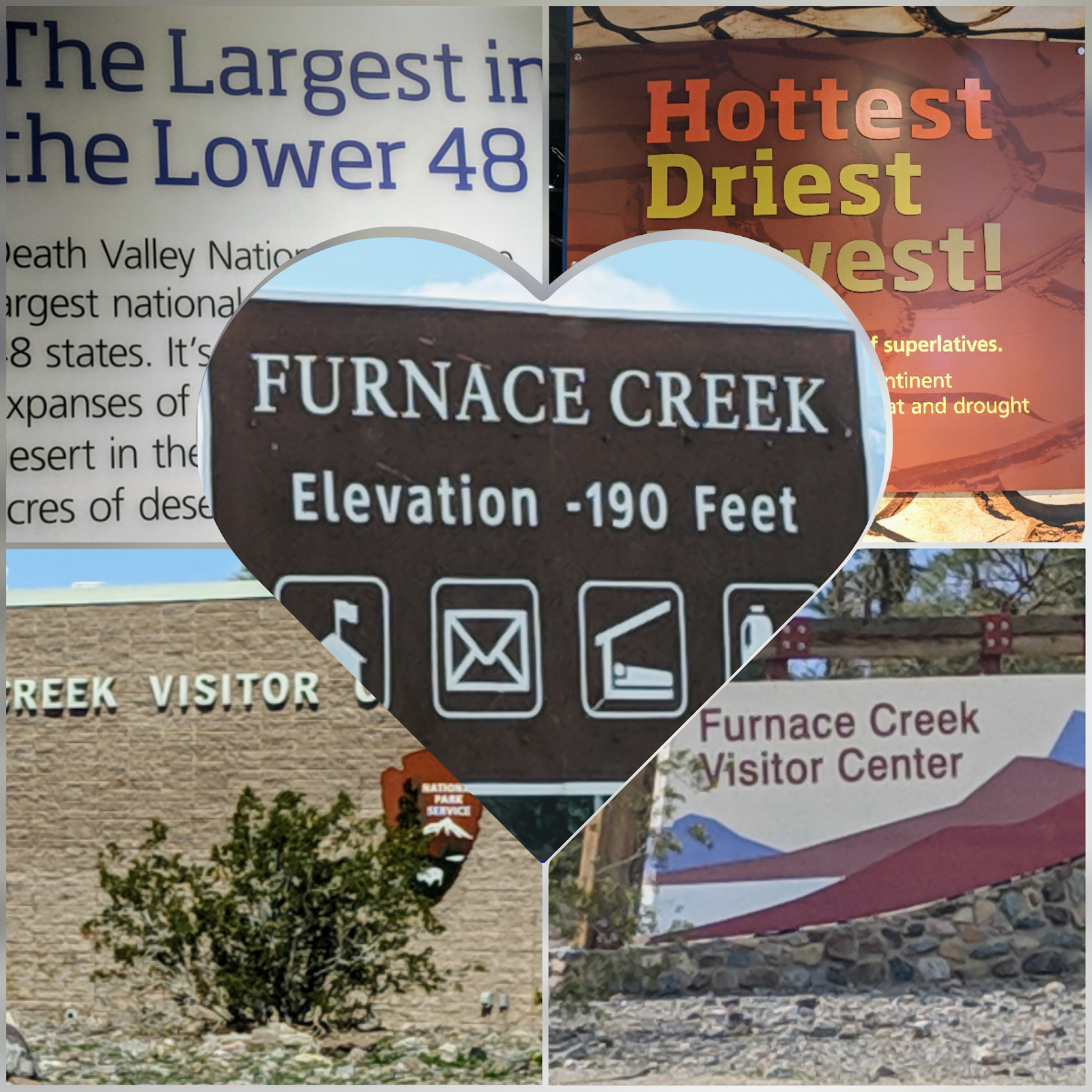
The park’s 3.4 million acres stretch across two states, California and Nevada. The highest elevation is the top of Telescope Peak at 11,049 feet and the lowest is -282 feet at Badwater Basin.

There is a lot to do and see in Death Valley …


Dantes View – the steep, elongated mountain ranges alternate with flat, dry desert valleys; the result of an intense stretching of the crust that has resulted in a series of north-south faults. Dante’s View is more than 5,000 feet above the valley floor; you can see across most of 110-mile long Death Valley.  The white salt flats below make up Badwater Basin.


Harmony Borax Works – A mining operation that dates back more than 120 years.  After prospectors found borax in 1881, William Tell Coleman built the harmony plant and began to process ore.  Operating at capacity, the Harmony Borax Works employed 40 men who produced three tons of borax daily.

The miners used the famed 20-mule teams to haul borax 165 miles to the railroad town of Mojave. The teams averaged two miles an hour and required about 30 days to complete a round-trip.  And to think I just open a box ….


Badwater Basin – With the Black Mountains in the background, Badwater Basin is the lowest point in North America, at 282 ft below sea level.  You can see the salt flat from your vehicle, or take a short walk onto the salt flats.  Two to four thousand years ago the basin was the site of a 30-foot-deep lake that evaporated and left a one-to-five foot layer of salt in its wake.


Part of the reason for this stop in Death Valley was about seeing the desert flowers.  Alas, there are none.  The ranger explained that they have to have rain in October, which they didn't; it came too late for Death Valley to bloom.  The rain did, however, bring a super bloom to the Anza Borrego desert, where I am not.  Seems to be the norm for me since I started this lifestyle.  Not to fret - I have seen some amazing things - such as the above sights.

Tuesday, March 5, 2019

Nevada Fun Facts

Nevada Facts and Trivia

  1. In 1899 Charles Fey invented a slot machine named the Liberty Bell. The device became the model for all slots to follow.
  2. The Reno Ice Pavilion is a 16,000-square-foot rink once dismantled and moved to Reno from Atlantic City, New Jersey.
  3. Bugsy Siegel named his Las Vegas casino "The Flamingo" for the long legs of his showgirl sweetheart, Virginia Hill.
  4. The Imperial Palace on the Las Vegas strip is the nation's first off-airport airline baggage check-in service.
  5. Bertha was a performing elephant that entertained for 37 years at John Ascuaga's Nugget casino located in Sparks. She was 48 years old when she died.
  6. There were 16,067 slots in Nevada in 1960. In 1999 Nevada had 205,726 slot machines, one for every 10 residents.
  7. While Samuel Clemens took the penname "Mark Twain" as a reporter working for the "Territorial Enterprise," he began his writing career as a reporter in the Midwest some years before moving to Virginia City in 1862.
  8. Pershing County located in Cowboy Country features the only round courthouse in the United States. Update: {the Bucks County Courthouse in Pennsylvania, constructed in 1960, is considered round. Now there are two.}
  9. In 1931 the Pair-O-Dice Club was the first casino to open on Highway 91, the future Las Vegas Strip.
  10. In March 1931 Governor Fred Balzar signed into law the bill legalizing gambling in the state.
  11. Once the highest concrete dam in the world, Hoover Dam offers guided tours and a museum of artifacts of the construction and its workers.
  12. In Death Valley, the Kangaroo Rat can live its entire life without drinking a drop of liquid.
  13. Construction of the Nevada State Capitol located in Carson City was proposed on April 14, 1870. Carson City is one of the smallest state capitals in the country. Update: {With current growth, may now be 14th smallest.}
  14. The ghost town of Rhyolite still pays homage to early pioneers and their dreams. Remains of the depot, glass house, bank and other buildings are on display.
  15. In Tonopah the young Jack Dempsey was once the bartender and the bouncer at the still popular Mispah Hotel and Casino. Famous lawman and folk hero Wyatt Earp once kept the peace in the town.
  16. The first recorded white men in the Elko area were fur trappers who trapped beaver in the area starting in 1828.
  17. The first community college in Nevada opened in Elko in 1967. Great Basin College was the forerunner of a statewide system associated with the University of Nevada.
  18. Berlin-Ichthyosaur State Park is constructed around the fossilized remains of ancient, mysterious reptiles within a well-preserved turn-of-the-century Nevada mining camp.
  19. The ichthyosaur is Nevada's official state fossil.
  20. Austin's oldest church, St. Augustine, requires the establishment's bells in the tower to be rung by pulling a rope located in the men's restroom.
  21. Nevada takes its name from a Spanish word meaning snow-clad.
  22. Most of the state is desert but the Sierra Nevada mountain range near Reno and the Ruby Mountains near Elko has snow for half the year.
  23. Locals use terms like The Sagebrush State, The Silver State, and The Battle Born State as nicknames for Nevada.
  24. Nevada is the seventh largest state with 110,540 square miles, 85% of them federally owned including the secret Area 51 near the little town of Rachel.
  25. Nevada has more mountain ranges than any other state, with its highest point at the 13,145 foot top of Boundary Peak near the west-central border.
  26. Grammatically, the proper term for the mountains is the Sierra Nevada not the Sierras. Robert Conrad almost called one of his television series High Sierra Rangers but changed it to High Mountain Rangers.
  27. Wayne Newton owns a home in the Las Vegas area, and it was a real location for the film "Vegas Vacation."
  28. The longest running show in Las Vegas is the Follies Bergere at the Tropicana Hotel and Casino. It opened in 1959. The production numbers in "Showgirls" were written specifically for the Paul Verhoeven film and shot in the Horizon Hotel at Lake Tahoe. The bulk of the movie used locations located at the Luxor and the Forum Shops at Caesars.
  29. You see the name Hughes on numerous locations and developments. Howard Hughes bought up considerable Nevada property before he died in 1976, including the following hotels and casinos: Castaways, Desert Inn, Frontier, Landmark, Sands, Silver Slipper, and Harold's Club. Part of the Hughes legend was recounted in Jonathan Demme's "Melvin and Howard."
  30. Misfits Flats off Highway 50 near Stagecoach takes its name from the John Huston film. Huston used the privately owned area to film a complicated wild horse round up with Clark Gable, Marilyn Monroe, Montgomery Clift and Eli Wallach.
  31. Nevada is the largest gold-producing state in the nation. It is second in the world behind South Africa.
  32. The state has about 50,000 miles of paved road, much of it featured in films like "Vanishing Point," "Breakdown," "Rainman," and "Lethal Weapon 4."
  33. Hoover Dam, the largest single public works project in the history of the United States, contains 3.25 million cubic yards of concrete, which is enough to pave a two-lane highway from San Francisco to New York. The dam face was used in an amazing stunt for Roland Emerich's "Universal Soldier" and has been seen in such films as "Viva Las Vegas" and "Fools Rush In."
  34. The Virginia City steam train still operates and was featured in the Imax project "Mark Twain's America." The "steam train" is a modern-day tourist train and does not link back to the original Virginia & Truckee RR which had its last run to Virginia City in 1938.
  35. The state's Highway 50, known as the Loneliest Highway in America, received its name from "Life" magazine in 1986. There are few road stops in the 287 mile stretch between Ely and Fernley.
  36. Frank Sinatra once owned the Cal-Neva at Lake Tahoe's Crystal Bay. It is possible to stand in both Nevada and California inside Cal-Neva's building.
  37. Nevada's smallest incorporated city is Gabbs located about 140 miles southeast of Reno.Update: {Gabbs, what was Nevada's smallest city was disincorporated on May 8, 2001}
  38. Nevada tribes include the Shoshone, Washo and Paiute. Tribal lands have been used in such film projects as "Misery," and "The Greatest Story Ever Told."
  39. The Las Vegas Strip is actually under jurisdiction of Clark County and can be seen in just about any film set in the city.
  40. Nevada is the only state with an entire museum devoted to the life and time of entertainer Liberace.
  41. Writer and commentator Lowell Thomas called Elko the last cowtown in America. Elko is the home of the annual Cowboy Poetry Gathering.
  42. Area 51 is acknowledged with State Route 375 officially christened "The Extraterrestrial Highway" in a ceremony featuring the director and cast of the movie "Independence Day." The highway runs between Alamo and Tonopah. There is a tiny restaurant stop at the Little Ale' Inn at Rachel.
  43. The only Nevada lake with an outlet to the sea is man made Lake Mead.
  44. Camels were used as pack animals in Nevada as late as 1870.
  45. To drive from Los Angeles, California to Reno, Nevada the direction traveled is to the west.
  46. Construction worker Hard Hat's were first invented specifically for workers on the Hoover Dam in 1933.
  47. Las Vegas has more hotel rooms than any other place on earth.
  48. Las Vegas has the majority of the largest hotels in the world.
  49. The longest morse code telegram ever sent was the Nevada state constitution. Sent from Carson City to Washington D.C. in 1864. The transmission must have taken several hours.
  50. Virginia City is the home of the Nevada Gambling Museum.

West of Las Vegas


It was raining, but I finally got my picture of the Welcome to Fabulous Las Vegas Sign.  What would a trip to Las Vegas be without stopping and taking pictures in front of the most recognizable sign in the world? Standing over 25 feet tall the Welcome to Fabulous Las Vegas Sign has been a landmark since its construction in 1959 and was designed by Betty Willis for only 4,000 dollars.

The rain brought with it some wind and about a 30-degree drop in temp since yesterday.

Al Capone's Car, a "bulletproof gangster car", owned at one time by mobster Al Capone, and Bonnie and Clyde's car.  There is a mini-museum of artifacts that is interesting.


Pioneer Saloon - Established in 1913, the Pioneer Saloon is a local watering hole that "may be the nation's oldest stamped-metal building".  

I had the Carol Lombard for lunch.  It was really good - basically a breakfast burrito, but it hit the spot.  I passed on the hamburger because they were 1/2 lb or more and I didn't want that much beef.  Service was slow, mostly because the food is prepared in another building and they had to carry it over through the rain.

The weather report showed a couple hours of rain overnight; it rained very cold rain all night and all day.

Red Rock Canyon National Conservation Area - These colorful sandstone palisades, only 17 miles from the Las Vegas Strip, are among the area's most impressive sights. Hiking trails and a 13-mile scenic drive provide dramatic views of the cliffs and canyons.
  
Several signs remind you to be aware of the desert tortoise crossing the road.  If you ride, I image seeing the canyon from horseback would be awesome.

The “red” rock formations are Aztec Sandstone.  What you see is the fossilized cores of old sand dunes laid down during the early Jurassic Period.  The sand slowly changed into sandstones as subsurface water percolated through the sediments, depositing iron oxide and calcium carbonate in the pore spaces between the grains.  These sandstone formations were slowly uplifted thousands of feet to their present elevation and exposed to weathering and erosion.

The “white” rock is Limestone.

The “golden/brown” rock was caused by the Keystone Thrust Fault.  The Pacific plate began moving under the North American plate, causing compressional forces to push up older limestone rock layers over younger sandstone rock layers.  At Red Rock Canyon, this is visible as grayish carbonate or limestone layers over red and buff colored sandstone.


Seven Magic Mountains, a desert art installation featuring 7 painted boulder totems up to 35 ft. high by Ugo Rondinone.  He did this in April 2017. 


I did find an alternative to using McDonald's as my pitstop.  Circle K - good price on gas, cheap soda, a clean bathroom - what more can a girl ask?

Monday, March 4, 2019

Starting my Nevada tour - driving East from Las Vegas

As you know by now, I try to spend a month in each state (even if I have to do it in sections).  I'm just starting Nevada and my first impression is Wow.  I had no idea.  I'm in the Las Vegas area for my first week.  Think casinos and shows.  Not so .... first of all, Las Vegas is huge.  I drive 20 miles in any direction and I'm still in "Las Vegas."  and the scenery is spectacular.

Lake Mead is beautiful.  I found myself taking so many pictures .... I couldn't get enough of the lake or the recreation area. Lake Mead National Recreation Area, water impounded from the Colorado River by Hoover Dam, is the first NRA
and was established in 1936.


Hoover Dam:  This massive engineering marvel stands 726 feet tall and weighs more than 6.6 million tons. It was constructed during the Great Depression from 1931 to 1936 to generate power as well as control flooding and foster irrigation. In the process, the dam formed Lake Mead, the nation’s largest reservoir, with 759 miles of shoreline.


Hoover Dam (they search your car when you enter) was so crowded I didn't bother to try for a tour.  The lines rivaled any at Disneyland during Spring Break.  They wanted $10 to park if you could find a spot.  One advantage to all the people was that I got to take pictures while I waited for them to cross the road.  I tried to go through to the Arizona side, curious if you could enter from both sides, but found it blocked.


 And the Valley of Fire State Park.  Valley of Fire derives its name from red sandstone formations, formed from great shifting sand dunes during the age of dinosaurs, 150 million years ago.  Complex uplifting and faulting of the region, followed by extensive erosion, have created the present landscape.


Boulder City is a nice town.  In the historic downtown area, they have these metal sculptures everywhere that are delightful. 
I also made a stop at the Acacia Demonstration Garden.  Like most demonstration gardens, the City of Henderson's Acacia Demonstration Gardens aim to inspire homeowners with ideas for their gardens at home. In this case, the city-sponsored facility provides examples of drought-friendly trees, shrubs, and flowers that are perfect for Nevada's desert climate. Meandering pathways throughout the garden lead visitors from one area to the next, bringing them face-to-face with species such as crate myrtles, quail bush, feathery cassia, and ocotillo flowers. Different individual areas highlight different types of plants—in the Allergy-Free garden, for instance, all of the plants have little pollen; the Wildlife-Friendly Garden features plants that historically have attracted desert birds and other kinds of wildlife.  I was disappointed that everything was still dormant, but the day was beautiful and the walk was pleasant.

Lastly, I attempted to take a picture of the Welcome to Las Vegas Sign, but there was no place to pull over, so settled for this one.

Sunday, March 3, 2019

Leaving Arizona and entering Nevada ....


I managed to get to one more National Monument before leaving Arizona.  Taking its name from the Aqua Fria River, the Agua Fria National Monument features one of the significant systems of prehistoric sites in the American Southwest.

It's a long, tough drive in and they recommend not going in the summer months, but can prove to be a great place to hike and explore the past.


The campground I stayed at in Congress had lovely flowers in bloom, now that the snow is gone.

But before the snow melted ..... I took a drive to the Shrine of Saint Joseph of the Mountains in Yarnell.  Unfortunately, it was closed due to the snow and ice (you couldn't get past the gate), but I managed a couple of distance shots .... The Shrine was constructed by a group of lay men and women (not all of whom were Catholic).  The result is Stations of the Cross that are magnificent.  The Shrine miraculously escaped destruction in the Yarnell Hill Fire of 2013, in which 19 firefighters were killed.  There is a memorial to these firefighters near the Shrine.
It is a peaceful experience to climb and meditate on the various Stations of the Cross.


I took a longer route out of Arizona in order to stop at Searchlight, Nevada because I heard their Historic Museum was worth a stop.  Since I've been on the road, keeping track of the days is a little bit of a challenge .... I was traveling on Sunday and the museum was closed when I arrived.  Oops ....

But, the drive was very nice and worth the extra few (about 30) miles.  US 93 is the Joshua Tree Forest  Parkway of Arizona and a state scenic route.  It was sort of like driving through Joshua Tree National Park, except the rocks weren't nearly as big

It also gets the prize for the longest grade I've driven down, except maybe the Blue Ridge Mountains. This one was 6%+ for about 10 miles.  Maybe it just seemed so long because it was straight down; no curves or anything.
I attempted a picture of Frog Rock when leaving Congress, but search as I might, I couldn't find it,    But I did manage a picture of Snoopy as I drove through Wikieup!  Snoopy must have gone Peanuts! He's riding a rocket! Who made him mad? That dog always was too quiet. Oh no! Woodstock is on there too?! That poor, poor bird. He just wanted to fly so badly, didn't he? No one knows why Snoopy is on the rocket, but there are three different Snoopys sitting on a missile as if they're at the horse races.


The highway between Searchlight and Las Vegas is their Veterans Memorial Highway (I think every state has one).  What made this one unique was that a section was devoted to the veterans of a specific war or conflict; but even more unique and special was that there were sections devoted to the veterans of the Cold War, the Persian Gulf, and the War on Terrorism (911).  There was fantastic scenery along this highway, but trying to take a picture while you're driving just doesn't do it justice.


I definitely earned my state sticker for Arizona!

Sunday, February 24, 2019

National Parks

A large part of the reason I'm in this area is to see the several National Parks and Monuments here.  Unfortunately, with all the snow, most of the trails are closed. 

Tuzigoot National Monument was the first stop.  Tuzigoot is an ancient village built by the Sinagua culture between 1000 and 1400.  It crowns the summit of a long ridge rising 120 feet above the Verde Valley.  The original pueblo was two stories high in places, with 87 ground-floor rooms.  Tuzigoot is Apache for "crooked water".  The visitor's center was open, but the trail to the monument was closed and covered with ice.


The next stop was the Verde Canyon Railroad.  There is a railroad museum but the main attraction is a 4-hour train ride through the Verde Canyon, traveling from Clarksdale to the Perkinsville ghost ranch and back.

 
Cottonwood is surprisingly good sized; a city actually.  I was expecting both Cottonwood and Camp Verde to be just mountain towns.


Despite the temperatures never getting above the high 20s and low 30s, it was a beautiful drive. The sun was shining and no wind.

Montezuma Castle National Monument - Southern Sinagua farmers built this five-story, 20-room dwelling sometime between 1100 and 1300.  It occupies a cliff recess 100 feet above the valley.

The river is Beaver River, which was used for the water source.


Montezuma Well - It is a lake in the middle of the desert; a limestone sink still fed by continuously flowing springs.  Every day the Well is replenished with 1.5 million gallons of new water.  There is a tiny amphipod, looks like a shrimp but is no bigger than your smallest fingernail, that lives in the Well and is not found anywhere else on earth.  Also unique to the Well is a spring snail and a single-celled diatom.


A pleasant winter walk along the Rim Trail


The next stop was Walnut Canyon National Monument - Dwellings sheltered by overhanging cliffs were home to Walnut Canyon's only permanent inhabitants more than 800 years ago.  The cliff dwellings were occupied for little more than 100 years.


Sunset Crater Volcano National Monument (with snow .... and without)

Sunset Crater Volcano was born in a series of eruptions sometime between 1040 and 1100. Powerful explosions profoundly affected the lives of local people and forever changed the landscape and ecology of the area. Lava flows and cinders still look as fresh and rugged as the day they formed.

Wupatki National Monument
   

And then I stopped to eat at the Galaxy Diner in Flagstaff and stepped back into the 1950s


I ended with a drive through Oak Creek Canyon and Sedona (elevation is like 7,000 ft) but they were pretty snowed in.  The speed limit on AZ 87A was 15-20 mph and between watching for ice on the road and all the potholes, I didn't get many pictures ... but even in winter, it is a beautiful area!

 Of course, Slide Rock and Red Rock State Parks were closed.


Very frustratingly my phone kept shutting off all day (bad battery?) so I'm not getting a lot of pictures, hence the "professional" brochure reprints on a couple of these.

Thursday, February 21, 2019

Moving from sunny Lake Havasu to freezing Cottonwood

Apparently, all roads in Arizona lead to Phoenix, because I found myself heading that way again, only this time I went out of my way a little and drove AZ60 instead of going back down I-10 for the 4th time.

I could have altered my itinerary and driven through Congress, or done the smart move and taken I-17 north to Cottonwood.  It would have put me within 4 miles of my campground .... but, no.  Even with a post-it on my calendar saying to check for the weather in the mountains, I decided to take the scenic route up AZ87 and AZ260, through Payson, to Cottonwood, with a major winter storm on its way. Unfortunately, because of the weather, meaning snow and freezing cold, I was not able to stop at the scenic points I intended along the way so the worry over the weather could have been avoided with the interstate.

It was nice to have the highway pretty much to myself, but it is also disconcerting to be the only vehicle heading north and climbing altitude the whole time.   I kept my speed under 45mph the whole way because I have a healthy fear of ice on the road.  Consequently, the trip took much longer than it should have, but as my son is fond of saying, "I'm retired and I have no place I have to be."


So now I'm sitting in Cottonwood, in thirty degree weather, watching the snow fall and wondering WHAT WAS I THINKING?