Wednesday, March 27, 2019

Winnemucca to Rye Patch SRA

I stayed three days in a BLM campground, Water Canyon, which is an awesome place to stay.  Unfortunately, because it is a "high use" area, the limit was three days instead of the normal 14 days on BLM land so I had to move on.

Not only did I have the place to myself, but I also had a babbling brook outside my door.  I loved the sound.

The local tourist guides suggested a drive to Paradise Valley.  It's about 40 miles north on US95 and NV 290.  I guess it's kind of a little beauty spot outside of the "city."  Hinkey Summit is a big draw, but it was closed because of snow.  A large creek, Cottonwood Creek, runs throughout the town and local ranches.  Like most of Nevada, this is open range territory and you can see cattle graze everywhere in large fields; they even come into town.

I took these pictures on my drive to Paradise Valley.

Besides the cattle, the other thing I have noticed about my time in Nevada is, if I'm not on the top of a mountain, I'm in a valley surrounded by snow-covered mountains.  I feel like I'm in a bowl.

The other constant in this state is that you can't throw a rock without hitting a ghost town.

Eight miles north of Winnemucca are some sand dunes that are very popular with the ATV crowd.  I drove by just to check them out; they are just sitting beside the road.  I don't know what caused them, but it seems weird for them to just "be there."

It started to rain on my drive back, hence the messed up windshield in the picture.


Because my three days at Water Canyon were up, I moved the coach south to Rye Patch State Recreation Area.  

While here I drove out to Unionville.  Maybe 20 people still live here.  The town was unusual to me because it was built along the main street which winds about 3 miles into Buena Vista Canyon, with no "side streets,"  long and narrow.  The other interesting thing was the economic difference in the houses; some were large range houses while others were actual shacks that didn't look habitable.  You wouldn't think anyone could live in them except for the propane tank, mailbox and satellite dish.

Mark Twain came here to do some prospecting, but only stayed a week or two.


In Lovelock I found a couple markers indicating the start of the California Trail in Nevada, a 40-mile stretch of "waterless Alkali wasteland."  The trail was considered to be "the most dreaded section of the California Emigrant Trail" by travelers.


My last stop in this area was Thunder Mountain Park, created by Frank Van Zant, a Native American Indian chief who made statues, folk art and other unique works and spread it across a five-acre "park of art"  Creations are made from bottles, chicken wire, windshields and other parts of cars, among other items.

Sunday, March 24, 2019

Belmont, Nevada

Today's drive was interesting.  On the recommendation of a friend, I drove to Belmont on NV 377.

Belmont began life in 1865 with the discovery of silver nearby.  The town thrived and within two years, the population had swelled to over 4,000 people.  As several of the mines closed, residents and businesses started to leave.  By 1890 most had left town.  In 1905 the county seat was relocated to Tonopah, sealing the town's fate.


Unlike many other old Nevada mining towns, numerous buildings still stand in Belmont, like the historic Belmont Courthouse, which is part of the Belmont Courthouse State Historical Park.

The location is very remote, thus requiring a bit of effort to reach.  The closest town is Tonopah, about 50 miles.  The road from Manhattan on NV 377 is dirt, but because it is at 7700 feet, this time of year it is snow and mud.  The part of the road with snow was actually much easier to navigate than the road without ....that one was pure mud and I had to use 4-wheel drive to keep from sliding and spinning.  People comment that I am "brave" or "adventurous."  My response is there is a thin line between that and stupid and I cross it on a regular basis. 😓

In the morning I am off on another adventure.  I'm heading north to Winnemucca to experience the brothels.  Wish me luck, as snow is again in the forecast.  I have about 2 weeks left in Nevada and still lots to see!

Saturday, March 23, 2019

Tonopah, Nevada

We had a thunder/rain storm yesterday that is typical for the desert; at least, it's the only place I have experienced storms so violent.  I was thankful I was in for the night, warm and dry.

Earlier, I drove to Goldfield, about 27 miles straight (and I do mean straight!) south on Highway 95.  In its heyday, Goldfield was one of the most booming towns in Nevada. 
 
The historic Goldfield Hotel has been the site of a number of reported ghost sightings and hauntings and has been featured on The Travel Channel.

And then there was the Main Street


Back in Tonopah, the Central Nevada Museum is an indoor/outdoor museum that tells the stories of the Old West mining boom and pioneer life.  Indoor exhibits feature Native American artifacts, fossils, wildlife, mineral displays, art, mining artifacts and military artifacts of the period.  The admission is by donation only.  Outdoor exhibits include an old west town, a railroad yard and mining equipment.

Tonopah also has a Historic Mining Park and self-guided walking tour if you are interested.

Friday, March 22, 2019

Highway 6 (Ely to Tonopah)

So I drove the 66 miles from Great Basin to Ely, a drop in altitude from 7500 feet to 6400 feet and spent the night.  And again, of course, it's snowing.  I spent the night at a travel center/Chevron in the dirt lot behind and watched the snow fall, not giving any thought to my slides being out or my satellite dish being up.  Not one of my smarter moments.  I'm calling 511 all night for the road conditions and being thankful they were downgraded from chains needed to winter driving conditions, and checking the lot to be sure the snow doesn't get too deep to drive out, but never gave a thought to the snow accumulating on the top of my slides.

In the morning, I can't bring in my slides or lower my dish.  The snow that fell was very wet and heavy and now I have a problem.  What to do?  I can't wait out the weather and hope the snow melts because three more days are forecast and the high is 40 degrees.

After I quit kicking myself, I walked out to the man plowing the parking lot and asked for his help.  He went to get his boss and after we all discussed options, they got a ladder and a snow scraper and cleared my slides so I could bring them in.  They also managed to get enough snow away from the dish so I could lower it most of the way, enough to drive.  Several times in the years I have been full time I have had "angels" come into my life to help me.  This was one of those times.  I have really been very lucky.

Although I haven't seen the rest of Highway 50 yet, I'm thinking maybe Highway 6 should be the Loneliest Highway.  There is nothing!  It is 178 miles from Ely to Tonopah and no services.  You better have a full tank when you head out.  There weren't even other cars traveling either way.

I had to cross two summits, one at 7100 feet and the other at 7700 feet, but when I was past them the weather warmed up to the low 50s, all the snow melted from my vehicles, and the sun was shining.

Although there is a cold wind, with rain predicted for tomorrow, the forecast is for 60 degrees the rest of the week.  I'm staying here for a few days!

Wednesday, March 20, 2019

The drive from Death Valley National Park to Great Basin National Park

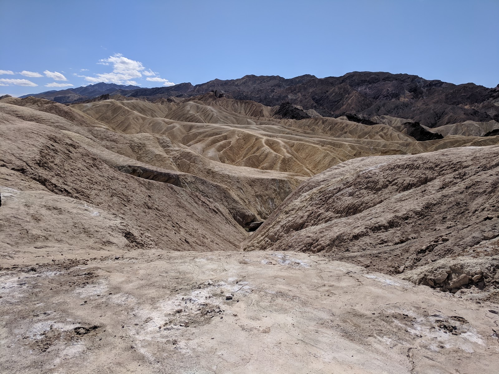
First I have to say .... quite the change in temperature!

My first stop was a few days in Pahrump, Nevada to see my son and daughter-in-law and meet my new Grandpup, Oswald.  Isn't he adorable?

The weather was sunny and warm, the high 70s.  I should have stayed here a few more days, but I'm always anxious to get back on the road, so ....off I go to see Cathedral Gorge State Park.

Volcanoes, earthquakes, water, and erosion created the spires and buff-colored cliffs of Cathedral Gorge.  There are lots of hiking trails and slot canyons, etc. to explore here.  I took these pictures from Miller Point.

There was some construction on the highway and we were led through by a pilot car, so as a result, several vehicles were "bunched" together on the highway for a while.  As we arrived at a turnoff for highway 318, all of the vehicles turned except me.  I was torn between being glad they were turning and wondering if they knew something I didn't. 😏

A stop in Pioche is worthwhile.  Silver was found near here as early as 1863, and after the mines opened in 1869, the settlement boomed.  It gained notoriety as a trigger-happy, lawless town, the toughest in the West.  Local legend has it that not one of the first 70 entrants in its cemetery died of natural causes.

History is all around here, starting with the Million Dollar Courthouse, so named for its costly (some say corrupt) 60-year debt repayment on the initial 1871 construction costs of $26,400.  But when the bond retired in 1936, inflation hit it, and the cost of the courthouse swept up to a massive $1 million.


The Great Basin Highway is a Nevada Scenic Byway and is very pretty.   At Majors Place I turned onto my first leg of Highway 50, the Loneliest Road.  I'll be spending more time on this highway in a couple of weeks.

Between the wind and the grades, I got really bad gas mileage on this drive.  I was hoping my new wheel alignment would give me a little boost in the right direction, but it didn't help.

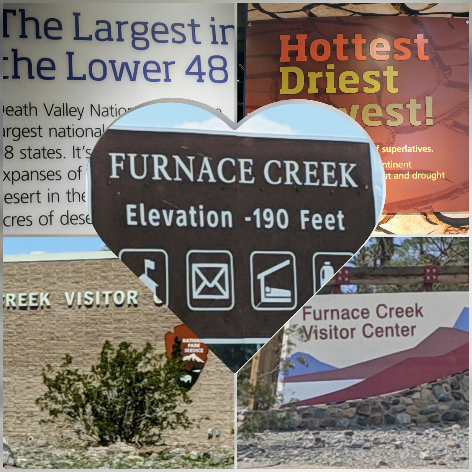
The Great Basin National Park sits a over 7,000 feet; remember I left Death Valley at below sea level.  This is what I found when I arrived ....


Unfortunately, the entrance to the 12-mile scenic Wheeler Peak drive (13,063 feet) was closed.

And this was my campground. 
When I'm traveling and the campground doesn't accept reservations, I'm always nervous that it will be full.  Not so this time.  I was the only guest.
The Great Basin National Park is home to some of the oldest trees, ancient bristlecone pines, found anywhere.  Also, a unique species of fish, the Bonneville trout, are only found here.  It even has it's own Great Basin rattlesnake!

It's not just one but many basins, separated by mountain ranges roughly parallel, north to south, basin and range alternating in seemingly endless geographic rhythm.  Broad basins hang between craggy ranges from California's Sierra Nevada to Utah's Wasatch Mountains.  Thirteen peaks rise above 11,000 feet.  You can definitely see mountains all around you as you drive into the park.

And below ground are the Lehman Caves (but it's actually only one cave), which extends a quarter mile into the limestone at the base of the Snake Range.  Lehman Caves is famous for rare formations called "shields" which are made up of two circular halves that resemble clam shells.      I got a good picture of the "bacon" formation as well.

The inside of the cave is 50 degrees, year-round, so it was actually warmer in the cave than outside.  It barely got to the low 30s while I was there; and it snowed, of course.                                                                                                        No one else was signed up for the cave tour the morning I reserved, so I got a "personal" tour from two very nice rangers.
I thought Baker would be a little bigger town, so was surprised that it's just a wide spot in the road.

I paid for two nights at the campground, but snow is falling and the weather report says it will continue to do so for three days, so I'm being causous and moving on.


Thursday, March 14, 2019

I ventured out of the park ...

...  to see another little piece of Nevada.

Rhyolite - One of the most photographed ghost towns in the West, Rhyolite was a mining town in the early years of the 20th century. A house made of bottles (restored in 2005), the railroad depot and various concrete ruins are all that remain.


The largest ghost town near Death Valley, Rhyolite boated a population of nearly 10,000 people during its peak between 1905 & 1911.  At its height, the town contained two churches, 50 saloons, 18 stores, two undertakers, 19 lodging houses, eight doctors, two dentists, stock exchange and an opera.


Amargosa Opera House - Not really an opera house at all, this eclectic desert icon, once the home of former Broadway dancer Marta Becket's ballet and pantomime performances, now offers only "sitting down" shows, in which the 80-something solo star narrates her life story and sings.


Ash Meadows National Wildlife Refuge - The 24,000 acres of spring-fed wetlands and alkaline desert uplands is so unique that it is recognized as a wetland of international importance.  Participants from various countries attended a convention in Ramsar, Iran in 1971, where they worked to provide a framework allowing countries to sign a treaty agreeing to voluntary international cooperation for wetland conservation.  These wetland sites around the world are known as Ramsar sites and Ash Meadows was one of the first Ramsar sites in the United States. 

Its the largest remaining oasis in the Mojave Desert.  Nearly 30 species of plants and animals that don't exist anyplace else on earth (referred to as endemic species).  Ash Meadows has the highest concentration of endemic species in the United States.  See relict species of desert fish that have existed here since mammoths drank from these very springs.   Have you ever heard of fossil water?  The water here is known as fossil water because it comes from melted ice from the last ice age.  

Devils Hole is over 500 feet deep and the bottom has never been found.
Devils Hole pupfish
The tiny inch-long pupfish that live in Devils Hole exist nowhere else in the world. 


Ash Meadows Amargosa Pupfish

Amargosa Pupfish - species exists only in Ash Meadows

Tuesday, March 12, 2019

Death Valley Part 2


There is no way to see this magnificent national park in a day or two ... I dry camped at Stovepipe Wells for a week and didn't see even half.


This is me ....


Something I've never had in a campground before ... my neighbor plays the bagpipes and is really good.  That was enjoyable.


Keane Wonder Mine – the best example of a historic gold mine in the park with an intact aerial tramway.  The three-mile road to the mine was very rough!
 
Ubehebe Crater – Hundreds of years ago, a massive volcanic explosion caused by Magna mixing with an underground spring left a 600 ft. deep crater.  You can walk around the rim (1 ½ miles).


 Views from the road

The only critter I saw while I've been here was a lone coyote and the occasional lizard.

  
A landscape of dark lava flows and volcanic cinders gives way to colorful layers of Rainbow Canyon.


There is a section of road on 190 west of Stovepipe Wells that is a fun, fun drive.  It is like a roller coaster and the speed limit is 65 mph.


 Zabriskie Point – A panoramic view of golden-brown mudstone hills riddled with rills and gullies from the occasional, but intense, times when water rushes down these bone-dry slopes.


Scotty’s Castle – A Spanish-style mansion built in the 1920s is currently closed due to severe damage caused by floodwaters in October 2015.  A series of powerful storms hit the area throughout October, washing out roads and damaging parts of the castle.  The powerful floodwaters moved part of a wall off the foundation and left the Grapevine Canyon area clogged with mud and debris up to 15 feet high in some areas.  It is expected to reopen at the end of 2020.  I plan to return in November 2012 for the encampment so I will see it then.    

The other "things to see" I missed this trip were the Artists Drive (closed), Mesquite Flat Sand Dunes and Charcoal Kilns and a number of hikes.  Something to look forward to.

More views of Badwater Basin
Beginning in the late 1800s a small number of burros escaped or were turned loose by prospectors.  The burros quickly adapted to the desert conditions and flourished, reaching a population of nearly 10,000. The National Park Service has embarked on a program to reduce burrow populations, which now number more than 500.

Apparently, Death Valley is a great place to bicycle.  Tour companies drop bikers off and there are bike paths available.

The wind came up the last couple of days while I was here and blew so hard that I got up in the night and brought in my slides to prevent any damage to the slide awnings.  Of course, the wind blew dirt everywhere.


I thought the price of gas at Furnace Creek of $4.43/gal was steep until I got to Panamint Springs; it was a dollar a gallon more than that. I was lucky to find some gas at Stovepipe Wells for $3.50/gas because driving around the park you are pretty much at their mercy, but if you're driving through, be sure to fill up your tank before you get close.  The nearest gas outside the park is like 30 miles away.

Saturday, March 9, 2019

Death Valley National Park


Death Valley became a national monument in 1933 and is famed for being the hottest, lowest and driest location in the country.  The parched landscape rises into snow-capped mountains and is home to the Timbisha Shoshone people.

The park’s 3.4 million acres stretch across two states, California and Nevada. The highest elevation is the top of Telescope Peak at 11,049 feet and the lowest is -282 feet at Badwater Basin.

There is a lot to do and see in Death Valley …


Dantes View – the steep, elongated mountain ranges alternate with flat, dry desert valleys; the result of an intense stretching of the crust that has resulted in a series of north-south faults. Dante’s View is more than 5,000 feet above the valley floor; you can see across most of 110-mile long Death Valley.  The white salt flats below make up Badwater Basin.


Harmony Borax Works – A mining operation that dates back more than 120 years.  After prospectors found borax in 1881, William Tell Coleman built the harmony plant and began to process ore.  Operating at capacity, the Harmony Borax Works employed 40 men who produced three tons of borax daily.

The miners used the famed 20-mule teams to haul borax 165 miles to the railroad town of Mojave. The teams averaged two miles an hour and required about 30 days to complete a round-trip.  And to think I just open a box ….


Badwater Basin – With the Black Mountains in the background, Badwater Basin is the lowest point in North America, at 282 ft below sea level.  You can see the salt flat from your vehicle, or take a short walk onto the salt flats.  Two to four thousand years ago the basin was the site of a 30-foot-deep lake that evaporated and left a one-to-five foot layer of salt in its wake.


Part of the reason for this stop in Death Valley was about seeing the desert flowers.  Alas, there are none.  The ranger explained that they have to have rain in October, which they didn't; it came too late for Death Valley to bloom.  The rain did, however, bring a super bloom to the Anza Borrego desert, where I am not.  Seems to be the norm for me since I started this lifestyle.  Not to fret - I have seen some amazing things - such as the above sights.